
A seed variety proven to thrive three villages away rarely reaches the farmer who needs it most — not because it wouldn't grow there, but because no one ever told her it would.
Picture a farmer in a drought-prone district, planting the same variety her family has sown for two generations, because it is the one she knows and the one the local shop sells. Somewhere in a government archive, on the other side of the country, a variety exists that was bred and proven for exactly her soil, her rainfall, her heat. It has a name, a registration number, a full record of how it performs under stress. She will likely never hear of it. Not because the knowledge doesn’t exist — but because it was published as a government gazette, a dense legal-technical PDF, never meant to be read by the people it was written for.
This is the quiet injustice at the heart of India’s seed system: knowledge that could change a harvest sits locked in a format only a lawyer or a bureaucrat could love. Every month, the Protection of Plant Varieties and Farmers’ Rights Authority publishes exactly this kind of record — which crop varieties exist, what conditions they were built for, how they resist heat and drought and salt. It is public information. It is also, in practice, almost entirely inaccessible.
Information should not require a law degree
We started this project on a simple belief: data that could help a farmer survive a bad monsoon should not be trapped behind bureaucratic language and page layout. A seed variety’s suitability to heat, drought or salinity is not a trade secret — it is public record, paid for and published by a public authority. But “public” only means something if it is actually reachable. Right now, that record lives across hundreds of dense, multi-column PDFs, written for compliance, not for use.
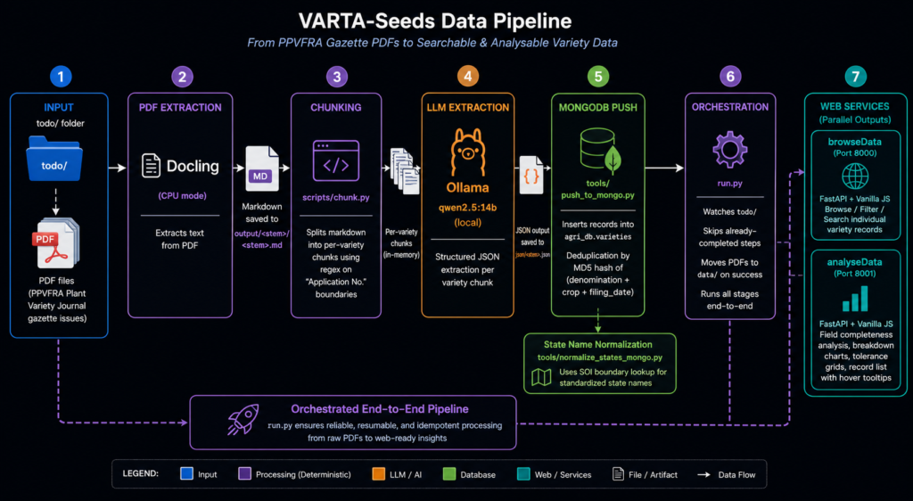
So we set out to do something unglamorous but overdue: read every one of those records, carefully and completely, and turn them into something a person could actually search, filter, and understand — for free, with no login, no paywall, no gatekeeping.
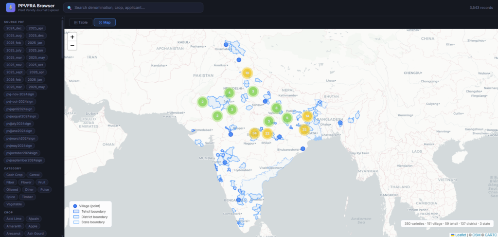
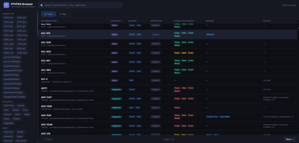
We’ve been working steadily through that archive, turning it into something searchable — by crop, by region, by how a variety handles heat, drought or salt — in a free public map and table that anyone can open in a browser, with more added as new records are published.
🔗 See it for yourself:
https://agri-doc-webapp.onrender.com
Climate doesn't read district boundaries
But making the archive readable was only half the problem. A variety’s official record lists the districts where it was formally registered — usually wherever the breeder happened to run field trials. That is an accident of paperwork, not a boundary of where the plant can actually grow. Two neighbouring districts can share nearly identical rainfall, heat and soil — and yet, on paper, a variety proven in one is treated as unknown in the other.
Nature does not consult a gazette before deciding where a plant will thrive. So we asked a different, more honest question: instead of “where was this variety registered?”, what if we asked “where does this variety’s real climate profile actually match?” — using the district’s real rainfall, temperature and soil data, not the paperwork trail.
Given a district's real climate, which registered varieties would genuinely suit it — including the ones bureaucracy never formally connected to that place?
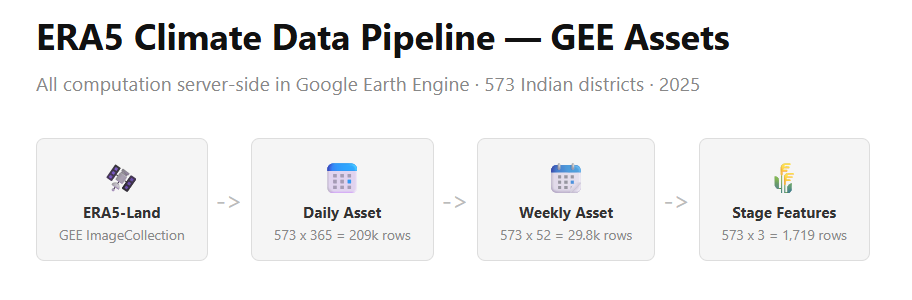
To answer that, we built a second layer beneath the archive: a climate profile for every district in India, computed from satellite and reanalysis weather data, broken down by each crop’s actual growth stages — because the week a rice plant is flowering matters far more to its survival than an average taken across the whole season. Matching a variety to a place, stage by stage, rather than season by season, is closer to how a farmer actually experiences risk: not “was this a dry year,” but “was it dry the week my crop needed water most.”
Built to be given away, not sold
Every choice in this project was made with one constraint in mind: none of it should end up behind a login, a subscription, or a paywall. The gazette data is public. The climate data is public. What we built on top of it — a searchable map, a filterable table, a growing archive of registered varieties — is free to use, and we intend to keep it that way.
This matters because the alternative already exists: seed companies with catalogs, marketing, and sales reps who reach some farmers and not others. Public data was supposed to be the counterweight to that — information that doesn’t depend on who your dealer is or which company’s flyer reached your village. We wanted to make sure that promise was actually kept, not just legally true but practically usable.
Where this is going
The archive is live and growing every month. The climate matching exists today for rice, as a pilot, with the same approach ready to extend to every other crop in the registry. What’s left is turning “these varieties match your district’s climate” into a tool a farmer, an extension worker, or a cooperative can actually use in the field — and that is not a problem we can, or should, solve alone.
- Agronomists — to check our matching logic against what actually happens on the ground, not just in the data
- Climate scientists — to sharpen how we read district-level risk through a crop's real growth stages
- Farmers and extension workers — to tell us whether any of this is actually useful, and how it needs to change to be
None of this replaces what farmers already know — generations of observation about their own land are still the deepest source of agricultural wisdom that exists. What we’re trying to build is a bridge: a way for the public record, paid for by the public and meant for the public, to actually reach the people it was written for.
This project works entirely from publicly-available PPVFRA gazette data and reproduces no copyrighted content. The archive grows every month as new gazettes are published.